

Introduction
The Bay Area will face multiple water related issues due to climate change. Extreme weather events will be more common, rain patterns will shift, and we will continue to endure droughts and reduced water flow. Additionally, sea level rise will pose a serious threat to homes, livelihoods, and industries located on our shoreline and along our watershed corridors. It is crucial that we address the complex, interconnected overlay of these risks on our region across multiple sectors. In order to do this, we must better understand the impact of each of these risks on our landscapes and communities.
Sea Level Rise
As the weather gets warmer, glaciers keep melting, and water molecules keep expanding from the rising temperatures, sea level rise (SLR) will continue to be a multifaceted global issue. We will all tackle it in unique ways dependent on the characteristics of our regions. Sea level rise can lead to increased coastal erosion, can exacerbate riverine flooding because of higher water levels, and will cause increased groundwater inundation, and threaten freshwater resources, among other indirect impacts.
To adapt to sea level rise, mitigate its impacts, and achieve equitable outcomes, Bay Area cities must work together. We need to consider our local unjust land-use history, development patterns, the risk of subsidence, and natural geomorphology in order to come up with comprehensive solutions. This section details the different elements of this multifaceted issue and includes recommended goals and policy interventions. Also, the State of California has issued guidance that helps planners and policymakers understand the likelihood of various SLR scenarios over time and how to incorporate those predictions into action (OPC Guidance 2018).
The San Francisco Bay Area is positioned to experience severe impacts as seas rise if no action is taken. “Adapting to Rising Tides Bay Area Report,” a regional analysis by the Bay Conservation and Development Commission (BCDC), forecasts how temporary and permanent sea level rise shoreline inundation events will cause permanent destruction to public and private property, worsen the affordable housing shortage, limit access to transportation networks, and further limit the property tax base local governments rely on.

Planning with Uncertainty
Technical climate experts agree that sea level rise is happening and coastal California is already seeing increased coastal flooding and erosion, but the speed and severity of impacts depend on several factors. Although models can provide good estimates based on past emissions, predictions after 2050 range drastically. That’s because we don’t know future global GHG emissions. This can make it difficult for planners to understand what type of measures are needed and how soon.
One solution is to use an adaptation pathways approach along with adaptive governance mechanisms that will allow for early action and subsequent adjustment over time. BCDC has applied the State guidance to their Adapting to Rising Tides work and their Flood Explorer tool, which uses “Total Water Level” (TWL) to represent nearly 60 combinations of permanent and temporary flooding above Mean Higher High Water (MHHW), a technical term used to mean the average height of the highest tide each day during a period. BCDC uses TWL to show the impacts that can come from sea level rise alone, but also how it can make king tides and storm surge impacts much worse.

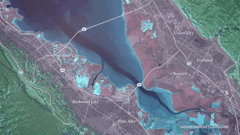
For example, 48” TWL is equivalent to 6” of sea level rise and a 100-year storm surge, or 24” of sea level rise and a 5-year storm surge in the Bay Area. BCDC data indicates that with 48” TWL (four feet) in the Bay Area, there would be over 80,000 acres flooded, 7,800 buildings destroyed, and 12,780 existing homes impacted, which doesn’t include any units constructed in flood-prone areas in the future (ART Bay Area, 2020). Days with 48” TWL will likely occur in the time frame from 2021 to 2060, and the most recent data indicates that it is not a question of if, but when.
What’s at Risk
What’s at Risk
Rising sea levels are slow-moving compared to the acute shocks of wildfires but their impact will be far-reaching and may drastically shape the ways our society functions in the Bay Area.
With a 4-foot increase in Total Water Level:
- 104,000 existing jobs and 355,000 homes will be lost
- $46 billion in economic assets
- Over 20,000 acres of the Bay’s coastal habitat (including Suisun Marsh, Eden Landing Ecological Reserve, San Pablo Bay National Wildlife Refuge, and many other wetlands and mudflats) will be severely damaged and no longer able to provide habitat to endangered marsh species, serve recreational uses, or buffer the shoreline from sea level rise and wave inundation (Bay Area Economic Institute 2015)
Additionally, the combination of warming water, an increase in nutrients coming from land with rising groundwater, and potential changes to the nutrient make-up can result in harmful algal blooms (HABs) in the Bay. HABs could affect human health and enjoyment of the coast and diminish ecosystem services we depend on.
For our most vulnerable communities, rising water levels have the potential to cause even more severe impacts. Communities with unstable housing, low-income status, and poor access to transportation options, among other factors, will be disproportionately affected.
Additionally, the combination of sea level rise and groundwater rise will directly threaten human and ecosystem health by mobilizing old contaminants that are often found near existing or former industrial sites like power plants, landfills, and water treatment sites, as well as more commonly found places like gas stations and dry cleaners. The high vulnerability of the Bay Area’s low-lying and shoreline communities are no accident —they are a product of past redlining and discriminatory land-use policies that put low-income communities in flood zones and next to locally unwanted land uses (LULUs). See the Environmental Justice section for more information.
Why is SLR a uniquely problematic issue in the Bay Area?
The San Francisco Bay’s history of heavy industrial uses, abundance of permeable sediment along the Bay’s edge, development of low-lying areas, and the dynamics of the relatively closed bay system create uniquely problematic conditions when addressing SLR and flooding. These overlapping conditions make adaptation complex and multifaceted and require planners and policymakers to account for inland flooding conditions, as well as shoreline protection.
The Bay’s unique dynamics means that uncoordinated adaptation actions could lead to new problems for neighboring jurisdictions, such as increased flooding, land subsidence, widening inequity, displacement of jobs, and loss of connected ecosystems. Instead, coordinated adaptation planning can be an opportunity to re-imagine the future in a way that is transformative, inclusive, equitable, collaborative, resilient, and sustainable. The Bay Area can use adaptation planning as a vehicle to link together existing planning processes while adding new layers of equitable practices and nature-based solutions. Collaborative and coordinated planning will not only address climate risks but also improve efficiencies, protect communities’ local tax bases, and uplift quality of life.
An effective science-based framework for developing adaptation strategies is the Adaptation Atlas, which is co-created by the San Francisco Estuary Institute and SPUR. The atlas proposes a new regional planning framework by dividing the 400-mile Bay shoreline into 30 distinct operational landscape units or OLUs. These geographic areas operate like “nature’s jurisdictions”—they cross traditional city and county boundaries but adhere to the boundaries of natural processes like tides, waves, and sediment movement. Sea level rise demands new governance mechanisms and management techniques, which are further explored in the Implementing Climate Policies section.
Experts agree that the Bay Area needs a comprehensive approach to adaptation and protection that includes integrated planning, collaboration across cities and counties, and participation by diverse stakeholders, and also takes into consideration the significant funding necessary for adaptation. The Metropolitan Transportation Commission (MTC) and the Association of Bay Area Governments (ABAG) have already taken steps to “establish a long-range plan charting the course for the future of the nine-county San Francisco Bay Area” around the issue areas of the economy, the environment, housing and transportation. This effort is called Plan Bay Area. The revenue assessment done for Plan Bay Area estimates that the cost to address the most pressing impacts from 24 inches of sea level rise through 2050 would amount to roughly $19.8 billion, only including shoreline protection projects. This amount includes $6 billion for marsh restoration and over $1 billion for managed retreat in the lowest density locations.

In the Bay Area, many utility providers are located along the shoreline in low-lying locations that depend on gravity to move waste and water rather than pumps which means they are highly vulnerable to imminent threats of SLR, but also motivated to lead innovative climate adaptation strategies.
As sea level increases, wastewater treatment plants will have shorter periods of opportunity to discharge into the bay, cracked sewer pipes will lose the capacity to infiltrate groundwater, and flow storage or pumping capacity will need to be increased. Additionally, the increase in sea level will cause “sunny day flooding,” impacting infrastructure that relies on underground systems that are either drained by gravity or have limited pumping power, such as stormwater and wastewater systems.
One exemplary solution is the Oro Loma Horizontal Levee, an innovative nature-based solution to SLR in Alameda County, that was led by the Oro Loma and Castro Valley Sanitary Districts. The horizontal levee concept (also called ecotone levees or living levees) aims to integrate flood control with habitat restoration in a way that can provide additional wastewater treatment while simultaneously providing ecosystem benefits—all with a much lower price tag as compared to gray water infrastructure alternatives.
As opposed to a traditional levee that is typically vertical in shape, a horizontal levee is built to provide a gradual slope from the Bay along with vegetation that can naturally reduce wave inundation and flood impacts (as seen in the diagram below). Treated fresh water from the sanitation facilities is filtered through the levee’s natural slope to the Bay, a process that removes more nitrogen, phosphate, and pharmaceutical traces than the standard wastewater treatment is able to (Estuary News 2020).
This final “polish” filtration on already-treated wastewater may be an effective way to filter out pharmaceuticals and other chemicals that are typically released into the Bay after standard treatment.
The Oro Loma project transformed a degraded area of baylands into a two-acre wetland that is able to naturally filter treated wastewater, provide extra wet weather water storage capacity, bolster local ecosystem services, and operate as a natural levee. The $7 million project, funded primarily by the sanitary districts, also serves as a living laboratory for experts to experiment with how different combinations of soil, plants, and slope operate under SLR conditions (Oro Loma Sanitation District 2015). The Oro Loma project provides an excellent example of how nature-based solutions can be designed and implemented through broad stakeholder collaboration, but there are still regulatory, governance, and funding barriers that are restricting projects like this from proliferating around the Bay.

Critical Actions to Take Now
- Develop a range of adaptation strategies that reflect “protect”, “accommodate”, “retreat”, and “avoid” approaches to SLR that work cross jurisdictionally and center community voices.
- Protect approaches typically refer to both natural and engineered measures to safeguard development in its current location. In contrast to retreat, these policies reduce exposure to the hazard without the removal of people or infrastructure (MTC, 2021). As part of the suite of “protect” policies, it is critical to proactively pursue nature-based and science-based planning and implementation of adaptation and mitigation strategies for sea level rise and land subsidence. However, nature-based “protect” strategies will only “buy time” in some locations where water will continue to encroach inwards, requiring either wetland expansion and migration to more inland areas, or eventual retreat.
- Accommodate approaches manage the threat of flooding on infrastructure, existing and future structures, and people. These policies may include reformed building standards and permitting of new designs like floating neighborhoods, terraced landforms, and transportation tunnels.
- Avoid policies seek to avoid future hazards by locating housing, utilities, and other development away from the most hazardous areas. Retreat strategies may include land-use designations, zoning ordinances, buy-out programs, and transfer of development rights (TDR) programs. If jurisdictions can implement retreat policies, they can successfully provide a long-term reduction in risk to their housing stock and community. These policies are more challenging to implement when there is existing infrastructure and development that require expensive and complex removal and relocation planning.
- Harness the power of nature by proactively pursuing nature-based and science-based planning and implementation adaptation and mitigation strategies for sea level rise, groundwater rise, harmful algal blooms, and land subsidence. Monitor natural functions that will further exacerbate flooding and SLR, including subsidence and groundwater rise.
- Engage in long-term visioning with community stakeholders. Sea level rise is a slow-moving hazard that will demand drastic changes to the Bay Area’s existing land use and development patterns in the long term. Many near-term adaptation options will only buy time for long-term relocation and retreat. In order to equitably facilitate long-term adaptation, communities should engage in long-term visioning exercises centered around best available sea level rise projections as a way to develop adaptation pathways and triggers that are reflective of the needs and wants of all community stakeholders.
Subsidence
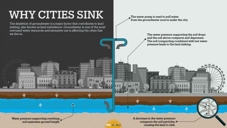
Subsidence—when land caves in or sinks—will further worsen the impacts of sea level rise. This phenomenon is most often due to both natural and human-induced processes. Natural occurrences, such as tectonic plate movement and sediment compaction, can cause gradual sinking in some environments. However, man-made processes that withdraw large amounts of water from deep underground through groundwater extraction, pumping, and management of water systems can cause more rapid and severe sinking of land.

This is a significant issue for areas on the Bay’s edge that were built with fill (landfill and sand) on former marshland and are now collapsing, partly due to declining water tables where pumping already occurs along with compaction of marsh soil structures. The majority of the Bay perimeter is undergoing subsidence estimated at roughly 6 mm per year (Blackwell et al., 2020). Places such as the San Francisco airport are sinking at rates of over 10mm a year, according to a recent study (Shirzaei and Burgmann, 2018).
If planning and development activities look at sea level rise projections alone, they could be missing vulnerabilities associated with overlapping hazards, especially subsidence.
Lack of planning around subsidence issues led to the situation with the Millennium Tower building in San Francisco that is now facing lawsuits after the 58-story luxury condo sank 18 inches after it was built in 2008 (Russell & McDowell, 2019).
Subsidence can effectively reduce the elevation of certain areas, making them more vulnerable to sea level rise and flooding. Additionally, infrastructure in the Bay Area is highly vulnerable to subsidence, which can have rippling effects on transportation networks and regional economies. Subsidence can also have negative impacts on coastal ecosystems that will become inundated as seas rise.
Critical Actions to Take Now
- Conduct and support ongoing studies and monitoring of subsidence activity at scales that are operable for determining the effects on a site-specific basis. While some recent studies have estimated subsidence rates in the Bay Area at a more granular level, this data is not widely available on an ongoing basis to planners and policymakers.
- Advocate for careful monitoring of these resources in order to help mitigate subsidence in vulnerable areas. As drought conditions worsen in California, groundwater resources will likely be drawn down even further. Manage water resources in a way that does not result in further subsidence.
- Integrate subsidence into studies of sea level rise policies. This will ensure that estimates of flooding and inundation associated with sea level rise are incorporating the best available knowledge and accounting for subsidence as a key factor in understanding that risk.
- Develop strategies for managing subsidence and protecting existing development. Consider retrofitting critical infrastructure to strengthen its foundations against subsidence when relocating or demolishing buildings is not an option.
Rising Groundwater
 Flooding is an issue that does not just affect coastal cities and habitats. Emerging research shows that, as sea levels rise, it can also lead to rising shallow groundwater tables which will lead to flooding hazards in more inland areas, regardless of available shoreline protection. Groundwater flooding is a significant issue, yet most of the adaptation planning work has not accounted for this flood risk. The strategies that have been developed to address overland flooding and storm surge may not be effective against groundwater rise. It is estimated that three feet of sea level rise can generate the same level of increase in the shallow groundwater table, which would result in flooding in low-lying areas, not along the shoreline (Bjerklie et al., 2012). Currently, pumping is the most common approach used to address high groundwater tables, but as sea levels rise, more pumps will be needed. Unmitigated groundwater rise could cause inland flooding in places where the pumps cannot keep up with the volume. Additionally, pumping will oftentimes increase subsidence rates (which means the land will sink and will increase the flood risk).
Flood Types:
Fluvial and Pluvial Flooding
Whenever the volume of water on land overcomes the capacity of natural and built drainage systems to carry it away or absorb it into the ground, destructive and dangerous flooding may occur.
Fluvial flooding occurs when rivers experience an influx of water that exceeds their capacity and leads to overflows. This may occur in tandem with rising seas or with pluvial flooding events.
Pluvial flooding refers to flood events caused by rainfall that overwhelm stormwater systems and groundwater infiltration capacity, resulting in dangerous and disruptive floods.
Rising groundwater levels lower the capacity for groundwater storage, which can result in greater flooding during pluvial flooding events and flash floods. The Bay Area needs to be prepared for this new challenge. Across the country, the annual cost of damage from inland flooding is higher than any other severe weather event—averaging $6.9 billion per year for the period between 1976–2006 (U.S. Climate Resilient Toolkit).
Climate change is expected to increase the frequency and severity of flash floods, or events with increased precipitation over a short time. San Mateo County conducted a Climate Adaptation Risk Analysis (focused on precipitation) to inform their Countywide Sustainable Streets Master Plan. This study found that incorporating green infrastructure into street design can meaningfully increase resilience during pluvial events. More specifically, their modeling showed that green infrastructure could completely offset increased runoff from 2-year storm (high frequency event) and even offset 40% of the runoff increase of a 10-year storm event (Carter & Riverson, 2020). Green infrastructure and nature-based stormwater management not only reduces the impacts of disruptive flood events, but also may translate into lower storm drain maintenance costs and lower costs for road repairs—which are public costs that are likely to grow in the face of climate change.
What’s at Risk
What’s at Risk
Groundwater flooding will have extreme consequences around the region in areas away from the shoreline. Many structures in low lying areas are already affected, and rely on sump pumps in basements and below-grade structures to remove water. Eventually, basements and below-grade living spaces will become more prone to flooding and storm sewer systems will experience reduced capacity during rainfall events, causing potential backups. Additionally, many electrical utilities and electrical connections are at risk of flooding damage.
While adaptation strategies to address rising groundwater are still in early stages, what is known is more traditional sea level rise adaptation strategies like levees and hardening shorelines will not protect communities from rising groundwater (Plane et al., 2019).
Contamination: Rising groundwater at contaminated sites could have implications for remobilizing contaminants that have been capped. Many contaminated sites remove the upper layers of contaminated soil and replace these layers with clean soil or a layer of permeable concrete or clay, which leaves residual contamination below the layers of clean fill. If rising groundwater flows into contaminants that are no longer monitored because they were considered contained, these toxic substances may start to move. This groundwater contamination could seep into a basement or a broken sewage pipe and people could breathe in the vaporized chemicals (Kilvans, 2021). This potential contamination would not only impact existing development, but could also poison critical habitat areas in and around the Bay, resulting in cascading ecosystem impacts.
Transportation Issues: Increased seepage could increase in the Bay Area Rapid Transit (BART) tubes that already experience groundwater flooding. Caltrans currently manages existing groundwater flooding along some roadways, but this flooding is expected to increase significantly.
Wastewater Systems: Wastewater treatment pipes are heavily used during large storm events. As the groundwater table continues to rise in response to sea level rise, groundwater-based infiltration into wastewater treatment pipes could occur, even in the absence of rainfall. This would reduce the pipes’ capacity for either wastewater or stormwater to flow through it, and could lead to sewer backups at the surface or in basements.
Critical Actions to Take Now
- Support ongoing studies and monitoring of groundwater rise, subsidence, and pluvial flooding. There is a strong need for additional data and monitoring of groundwater rise, subsidence, water tables, and stormwater management.
- Employ nature-based solutions by prioritizing green infrastructure solutions for stormwater management and encourage the development of a “living with water” approach in places with groundwater rise and subsidence risks. These green interventions offer multiple resilience and ecosystem benefits at a typically lower cost than grey infrastructure—such as a traditional engineered levee—which will not always lessen the impact of rising groundwater (Adapting to Rising Tides, 2019).
- Integrate groundwater rise into studies of sea level rise policies. It is critical to take an integrated planning approach that addresses rising seas and groundwater simultaneously—from the vulnerability and risk assessment phase through to adaptation implementation.
Drought
The Bay Area has a diverse water supply portfolio consisting of local sources (groundwater, local surface water, and recycled/reused water) and imported sources from federal, state, and local projects. More than two-thirds of the water supplied in the Bay Area is imported from outside the region via pipelines, canals, and aqueducts (Sommer et. al, 2021). California naturally has more hydrologic variability than any other US state, meaning that, on average, we have more years of drought and flood. However, persistent dry years, warming temperatures accelerated by climate change, growing agricultural water needs, threats to freshwater quality from saltwater contamination, and other impacts are exacerbating California’s water needs.

The Bay Area also faces growing water affordability challenges. The combination of declining real incomes for low-income Californians, rising cost of living, and rising water bills contribute to a growing share of residents facing trouble paying their water bills (CA Water Board, 2020)(CA Water Board, 2020). According to an article by the SF Chronicle, “San Francisco reported more than three times as many delinquent water customers at the end of last year compared with March, shortly after the coronavirus pandemic began. That’s pushed the city’s total outstanding balance up six times what it was, to more than $7 million,” (Alexander, 2021). Our region must come up with a variety of solutions to tackle the access and affordability of our water resources.
One way to grapple with these complex challenges is through regional interagency approaches. This is a growing topic of discussion for Bay Area water managers. The problems that arose during the record 2012-16 drought underscored the imperative for greater regional cooperation and many different examples of interagency approaches were born, like the CA Sustainable Groundwater Management Act (2014) coordinated by the Department of Water Resources, and the Bay Area Regional Reliability Drought Contingency Plan (2017), a partnership among eight of the largest Bay Area water agencies.
A need for better governance systems has also become evident as water managers have attempted to embrace a One Water approach in which drinking water, wastewater, stormwater, and recycled water are managed as an interconnected system. A challenge in realizing a One Water approach is that each type of water is governed by different agencies operating under different laws, regulations, and governing bodies, making it difficult for them to manage water cooperatively (U.S. Water Alliance, 2020). Additionally, addressing the region’s water needs sustainably requires increasing the coordination not only between control agencies, but also between the water agencies and their counterparts in land use and transportation.
What's at Risk
What’s at Risk
Water Availability and Quality: During periods of drought, ground and surface water quality is impacted, and water isn’t available for farming, manufacturing, or use in everyday activities like bathing, cooking, and washing dishes. The National Drought Mitigation Center maintains an online archive of drought impacts across many sectors, collected mainly from media accounts, called the Drought Impact Recorder.
Reduced availability of water has many negative impacts. Water is essential to the production of goods and services and when the water supply is depleted or disrupted, reduced productivity or closures can impact supply chains. Industries that are directly affected by drought include agriculture, recreation, energy, tourism, timber, and fisheries among others. Drought can have wide-ranging impacts that include job losses, business failures, and lost investments (APA, 2019).
When aquifers are low due to over pumping and inadequate recharge, freshwater resources may be susceptible to saltwater intrusion, which has become increasingly problematic with sea level rise (ibid). With less weight from fresh groundwater lying above, salty water can rise higher in the soil and potentially contaminate groundwater resources. Alameda County has been monitoring and managing the Niles Cones groundwater basin, which has experienced persistent and escalating threats of saltwater contamination. Saltwater intrusion resulted from depleted groundwater resources from heavy use by farms, ranchers, and a growing population, which lowered the groundwater level to below the sea level and allowed for salty water to migrate inland (ACWD, 2016). The Alameda County Water District has faced the challenge of managing this 100-year-old threat through conservation efforts and monitoring, but drought conditions and rising seas will likely worsen the contamination conditions.
The state of California introduced a new regulatory program, the Sustainable Groundwater Management Act (SGMA), which mandates local agencies to prepare groundwater sustainability plans, however resources and additional coordination is needed.
Environment: Drought also has significant impacts on ecosystems. When lakes and rivers have low water levels, they are less able to flush out contaminants, causing an increase in the concentration of waterborne pollutants. Reduced streamflow and low reservoir capacity can threaten aquatic ecosystems and inadequate access to freshwater resources and dry sources can have rippling effects. Drought may result in reduced plant growth; an increase in wildfire and insect outbreaks; altered rates of carbon, nutrient, and water cycling; and even local species extinction (NOAA).
Development: The Bay Area faces a tension between projections for population growth and its limited water supplies. The region is projected to add 2 million new jobs by 2070 (Levy, 2019), which will attract an additional 4 million people. To meet the demand, the region needs to build at least 2 million new housing units just to prevent housing inequality from worsening (Karlinsky, 2020). At the same time, a changing climate and regulatory environment are altering the quality, abundance, and predictability of the state’s water supplies and the availability of developable land (Ackerly, 2021). Affected communities appear on this interactive map, which illustrates municipalities that have implemented moratoriums on development due to water concerns.
While at least 37 communities in California faced with water shortages have placed moratoriums on new development (Building Moratoriums Map), other communities have taken a different approach, requiring instead that all new development offset their future water demand. However, water-neutral development policies are not without their challenges.
Infill, multi-family housing (see infill development) is responsive to drought constraints. If more infill housing is built, the region can increase its water efficiency, which will provide huge potential to continue the region’s trend of supporting new development without increasing overall demand.
Wildfire: While wildfires can occur during normal conditions, concurrent periods of drought and extreme heat create conditions that increase the likelihood and intensity of wildfires. This results from a decrease in water contained in the soil and increased temperatures, which then stress vegetation and increase plant mortality, providing fuel for fires (American Planning Association, 2019). Lower water levels can also limit withdrawal sources for fighting wildfires.
Flooding: Extended drought can stress vegetation and cause dieback and dry soils, which leads to increased runoff and flooding during rain events, as compared to normal conditions (Castillo et al., 1997). The area where a wildfire has taken place will also be covered in ash rather than bare soil, which is more water repellent and will not absorb future rainwater as well as previous soil. This can cause increased runoff rates, which could lead to a flood. This is most relevant in hilly areas where the gradient and increased runoff rate can create fast-moving water down toward flatter areas. Additionally, drought can increase land subsidence. As the ground sinks, the surface water runoff patterns can change, leading to flooding events in places that did not previously have flood risk (Wanamaker, 2018).

Case Study
Coyote Valley
Coyote Valley is positioned to become a national model of water-smart planning. Coyote Valley, which comprises 7,400 acres of greenbelt lands in south Santa Clara County, has an immense capacity to store groundwater that is critical to water supplies for thousands of people in the region. The estimated 1,758 acre-feet of groundwater recharge in Coyote Valley is equivalent in volume to the annual water use for about 9,015 households (Bay Area Greenprint, 2020). Santa Clara Valley Water District estimates the total storage capacity of the Coyote Valley to be between 23,000 and 33,000 acre-feet, representing the volume of usable groundwater that the basin is capable of storing at full capacity (SAGE, 2012). This is additional to the recharge occurring in-stream in Coyote Creek under Santa Clara Valley Water’s managed recharge program (Valley Water).
If developed, this freshwater resource is highly vulnerable to groundwater contamination due to the high water table and soil permeability (Greenbelt Alliance, 2020). Unlike most other locations in Santa Clara County, the drinking water aquifer is near the surface and is not shielded by an overlying impermeable layer. A contamination event that might not reach the groundwater table in other locations will likely reach it in Coyote Valley and then spread with the moving groundwater.
In 2019, the City of San Jose committed to explore Coyote Valley’s long-term future in its citywide General Plan Review. This process, slated for completion in 2021, will seek to reallocate planned development from Coyote Valley to urban infill locations and rezone Coyote Valley for agricultural and open space uses. This action by the City and ongoing land conservation efforts set the stage for Coyote Valley to demonstrate how natural and working lands can be managed for flood and groundwater protection, climate change resilience, wildlife habitat as well as avoiding greenhouse gas emissions and reaping carbon sequestration benefits from conserving and restoring Coyote Valley instead of developing it.
These efforts can serve as a template for wise management of watershed lands across the Bay Area. Today, roughly 1.2 million acres—more than a quarter of all the land in all nine Bay Area counties—catch and filter rainwater and replenish local water supplies (Stampe, 2017). Continued deployment of nature-based solutions to protect and restore these lands can safeguard water supply and quality.
Critical Actions to Take Now
- Map highly vulnerable groundwater resources and groundwater-dependent ecosystems around the Bay Area. By identifying high-priority groundwater resources and ecosystems that are highly dependent on groundwater, policymakers can better understand how to protect these resources from contamination and depletion.
- Prioritize the conservation of vulnerable groundwater resources as open space. Local and regional governments should employ a suite of plans and policies that protect open space from development to ensure sustainable groundwater resources for decades. Examples include establishing urban growth boundaries, urban service areas, and urban limit lines.
- Manage demand with efficiency and conservation. Prioritize areas in your community to locate infiltration-based green infrastructure practices such as rain gardens, planter boxes, and bioswales. Consider incentives or local requirements to encourage on-site rainwater harvesting. Include green infrastructure as part of long-range water planning efforts if your area is dependent on groundwater supplies for drinking water and irrigation.
- Diversify local water supplies. Develop a water supply portfolio that moves away from dependence on one water source such as imported water or groundwater, and utilizes a number of other water sources by incorporating local and regional solutions, including conservation and efficiency, water recycling and reuse, rainwater and stormwater harvesting, and desalination.
- Use dense development, like infill housing, as a demand management tool. Low-density development uses more water than high-density development largely because formerly unirrigated areas are converted to landscaping. By contrast, infill development tends to have less outdoor space per housing unit, and new buildings often occupy what has been previously irrigated landscaping, reducing the total irrigated area. investing in compact development and reducing outdoor water use can increase water efficiency. New developments should include nature-based solutions like permeable surfaces, bioswales, and green stormwater management practices.
- Address water affordability challenges. Explore different proposals to address the issue through low-income discounts, but ensure that these programs do not resolve the fundamental problem that the cost of drinking water is rising while wages for low-income households are declining.
- Create better systems for regional water planning, cooperation, and governance. Consider interagency collaboration opportunities and multi-jurisdictional approaches to address multi-hazard water issues. Sea level rise, subsidence, drought, and groundwater resources are closely connected and should be managed in a way that reflects this nuance.
Policy Matrix
Goal
Develop a range of adaptation strategies that reflect “protect”, “accommodate”, and “avoid” approaches to sea level rise adaptation.
| Strategy | Actions | Source |
|---|---|---|
| Accommodate: Reduce or prohibit development in the most hazardous areas. Hazards and climate impacts to consider are earthquake, liquefaction, flooding (riverine and sea level rise), groundwater rise, subsidence, landslide, and wildfire. | Require new development to plan for and protect against 100-year storm events (42 inches total water level) plus an additional 36 inches of sea level rise. Ensure that the design of future developments incorporate flood protection measures to protect improvements from a 100-year storm event and anticipated sea level rise. | D2 San Francisco Climate Action Plan , Sausalito General Plan , Alameda County Climate Action Plan |
| Preserve on-site natural elements in new development, when feasible, that contribute to the community’s native plant and wildlife species value and to its aesthetic character. | City of Alameda Climate Action and Resiliency Plan | |
| Consider incorporating sea level rise into the Flood Management section of the Building Code to encourage, incentivize, or require compliance with base floor elevation and flood-proofing requirements to mid-century sea levels. Consider unconventional design elements that may allow structures to accommodate a higher water table and higher liquefaction risks. | City of Alameda Climate Action and Resiliency Plan | |
| Establish a hazard or climate overlay zone. Apply an overlay zone to areas with the greatest current hazards and/or future climate impacts. Associate corresponding risk reduction,adaptation policies, and standards specific to the hazard or climate impact. Overlay zones should include development standards for appropriate risk mitigation measures like those found in the protect, accommodate, and consequence sections. | MTC Resilient Housing Policies | |
| Develop adequate setbacks or buffers for new development. Establish setbacks or buffers to ensure structures are set back far enough away from known or likely hazardous locations, such that they will not be endangered over the life of the structure, without the use of protective devices. Establish general guidance and criteria for setbacks that consider impacts from climate change and establish the expected life of the structure. | MTC Resilient Housing Policies | |
| Clearly define areas at risk. Include an updated inventory of potential pollutant sources due to sea level rise, including toxic waste sites, ocean outfalls, and wastewater treatment facilities at risk of inundation, as well as aquifers and wells at risk of saltwater intrusion. Policies may also be added to prioritize low-lying contaminated sites for remediation and restoration. | California Coastal Commission | |
| Maintain data on environmental hazards, such as soil and groundwater contamination and the vulnerability of the population to such hazards, using sources such as Cal Enviroscreen. Consider contamination hazards in concert with changing environmental conditions of SLR, groundwater rise, subsidence, and liquefaction that may mobilize or expose contaminants in new ways. | San Rafael General Plan | |
| Improve resilience planning for climate change, public health emergencies, and other community stressors among non-English speaking and lower-income populations. Increase awareness of sea level rise, groundwater rise, liquefaction, and flooding risks in vulnerable areas, as well as the importance of adaptation measures. | San Rafael General Plan | |
| Accommodate: Build infill, climate SMART multifamily housing instead of single family homes in greenfields. | Encourage development of missing middle and higher density housing types instead of expanding single-family development. | Los Gatos General Plan |
| Consider changes to the Municipal Code, including zoning regulations, that support houseboats, liveaboards, and other types of floating homes in areas designated as “Water” on the General Plan Map. | San Rafael General Plan | |
| Require water conservation features in all new developments including Xeriscape landscaping and low water use irrigation improvements. Use sustainable design practices including water‐saving systems and best management practices in developments. Promote the use of on‐site gray water and rainwater collection systems. | Imperial Beach General Plan | |
| Adopt a retrofit program to encourage or require installation of water conservation measures in existing businesses and homes. | Tiburon Climate Action Plan | |
| Encourage the installation of greywater and rainwater collection systems. Explore revisions to building codes that would facilitate such projects where obstacles currently exist. | San Rafael General Plan | |
| Encourage the use and integration of dual plumbing system hookups to accommodate recycled water into new development. | Hermosa Beach Integrated General Plan and Coastal Land Use Plan | |
| Consider effects on watershed areas, plant and wildlife habitats, and migration corridors before allowing development of any open space. | Los Gatos General Plan | |
| Accommodate: Require flood-proof construction methods, techniques, and mitigation. If it is infeasible for new development to avoid temporary flooding hazards with siting, development should be designed to minimize risks from flooding over the anticipated life of the development, and otherwise constructed using design techniques that will limit flood damage caused by storms. Amend local codes to require flood-proof construction techniques in structures in flood hazard zones. | Ensure design considers function under future sea level rise conditions and incorporates best practices for stormwater management. Develop or amend the community’s stormwater ordinance to prioritize low-impact stormwater best practices for private realm properties and allow for low-impact development (LID) regional management for multiple properties. Such best practices can encourage stormwater capture and aquifer recharge and reduce site and regional runoff, improving water availability during drought periods, reducing flooding during high precipitation events, allowing for more creative development, best citing of facilities, and potential for reduced individual development costs. | MTC Resilient Housing Policies |
| Avoid: Implement a policy of retreat or managed retreat program for areas at-risk for repeated damage due to climate change hazards, such as areas of high subsidence, extreme wildfire risk, and floodplains to allow for natural modification of the landscape and reduction in risk to property and life. A Managed Avoid Program would include standards that trigger when development is relocated, modified, or removed. | Identify thresholds or events that trigger a managed retreat action or new accommodate strategy. Actions may include the relocation or removal of vulnerable structures including the incremental relocation of structures on large lots, of structures off constrained lots, or the removal of structures and foundations. The policy may require consideration of existing nonconforming structure standards. | MTC Resilient Housing Policies |
| Identify priority areas for managed retreat to retain public access and sufficient beach area for recreational use; plan to relocate roads and infrastructure. | Santa Cruz Climate Adaptation Plan | |
| Implement measures to address the potential for loss or displacement of affordable or lower cost housing in the City’s climate change adaptation planning. | San Rafael General Plan | |
| Provide incentives to relocate development out of hazardous areas and to acquire at risk properties, where relocation is not feasible. May also consider an acquisition and buyout program which includes acquiring of land from the individual landowner(s) which are typically demolished or relocated with the property restored and future development on the land is restricted. Requires a supporting funding mechanism like a community land trust or repetitive loss program. | MTC Resilient Housing Policies | |
| Allow a landowner reasonable interim use of property in areas where development is presently constrained by factors such as circulation system capacity, infrastructure, and natural hazards such as flooding. Ensure that zoning regulations include provisions for reasonable interim uses for properties where the highest and best use allowed by zoning is not presently attainable due to traffic capacity, infrastructure, natural hazards (including sea level rise),and other factors. Examples of reasonable interim uses include contractor’s yards, modular or mobile uses, new car storage, parking, and outdoor recreation. | San Rafael General Plan | |
| Identify and fund high-priority housing densification strategies in areas where managed retreat will be necessary and incentivize building that type of housing now. | ||
| Avoid: Establish a Transfer of Development Rights Program. | Establish a Transfer of Development Rights (TDR) program, which could place permanent conservation or hazard mitigation easements on properties in high hazard areas to prevent or minimize the vulnerability of new development including but not limited to seismic, flooding, or wildfire hazards. These programs can provide compensation to property owners in areas with higher or increasing hazard exposure to relocate potential development to areas with less exposure to hazards. | MTC Resilient Housing Policies |
| Protect: Use agriculture and open space zoning to buffer development from hazards. Identify, map, and establish open space land-use designations in areas of high hazard that are also areas of significant habitat, biodiversity, carbon sequestration, and ecological integrity. This could include restricting new development in areas next to coastal, riverine, or upper watersheds with co-benefit to improve ecosystem functions and reduce exposure to climate and/or seismic hazards. | Streamline provisions within the community's zoning ordinance, including fees and internal routing for application approvals, to reduce barriers to use of the Williamson Act for preservation of agricultural lands and/or open space. This can aid in carbon sequestration, protection of food supply, inland floodplain protection, or sensitive habitats to offset costs and provide additional land to mitigate climate change impacts. The Williamson Act encourages the preservation of land for open space, forestry, and agricultural operations through an easement and reassessment of the property. | MTC Resilient Housing Policies |
| Adopt an Urban Growth Boundary (UGB), a line beyond which urban development is not allowed, through a voter approved ordinance, with limited exceptions for certain public facilities. The UGB will also be depicted on the Land Use Diagram, and, as a general rule, may not be amended for a specified length of time without a vote of the people. The boundary lines between most land-use designations are delineated as specifically as possible, generally following parcel lines. | City of Winters | |
| Support the preservation of agricultural and working lands, including rangelands, and restore forest lands, by limiting the conversion of these lands to residential or other uses through tools such as the creation of agricultural easements, particularly within high climate-hazard areas and Significant Ecological Areas. | Los Angeles County Climate Action Plan Draft | |
| Encourage land uses and improvements that reduce energy and water consumption, waste and noise generation, air quality impacts and support other comparable resource strategies for a sustainable City. | Imperial Beach General Plan | |
| Support regional watershed conservation through local land use planning, open space policies, and water quality conservation efforts. | Emeryville General Plan |
Goal
Harness the Power of Nature: Proactively pursue nature-based and science-based planning, implementation, adaptation, and mitigation strategies for sea level rise, groundwater rise, and land subsidence.
| Strategy | Actions | Source |
|---|---|---|
| Encourage innovative nature-based protection measures where most practical and feasible, such as wave attenuation projects, natural reef development areas, and ecologically friendly measures to combat sea level rise. | Allow construction that alters natural shoreline processes only when required to serve coastal-dependent uses or to protect existing structures or public beaches from erosion, and when designated to eliminate or mitigate adverse impacts on local shoreline sand supply. | Santa Cruz Climate Adaptation Plan |
| Require new development and substantial redevelopment projects to minimize impacts to existing public access to and along the shoreline. | Hermosa Beach Integrated General Plan and Coastal Land Use Plan | |
| Consider developing an inventory of the city’s drainage system and assess for potential wetlands reversion to adapt to sea level rise. | Sausalito General Plan | |
| Develop a program to work with public and private landowners to decrease the risk of flooding by advancing watershed management projects that reduce and/or store runoff during rainfall events, including the installation of green infrastructure and Low Impact Development (LID) practices, and improve the condition in the floodplain, for example through floodplain restoration or improvement. | ABAG/BCDC: Stronger Housing Safer Communities Strategies , Sausalito Climate Action Plan | |
| Adapt the existing park and open space network to rising sea levels, more severe storm events and wave energy, and rising groundwater. Secure adequate and reliable funding for the development, rehabilitation, programming, and maintenance of parks, community and recreation facilities, trails, greenways, and open space areas. | Sausalito General Plan | |
| Establish a City ordinance requiring that project proponents explore the potential for nature-based adaptation measures before considering hardened structures, which can direct wave energy onto adjacent shorelines and exacerbate erosion. Require incorporation of ecologically friendly features along seawalls and hardened shorelines (when possible) and where shoreline hardening exists or is planned, including public access for people walking or bicycling on seawalls or levees. | City of Alameda Climate Action and Resiliency Plan | |
| Under appropriate shoreline conditions, require or encourage development to use “soft” or “natural” solutions or “living shorelines” as an alternative to the placement of hard shoreline protection in order to protect development or other resources and to enhance natural resource areas. Examples of soft solutions include vegetative planting, dune restoration, and sand nourishment. | California Coastal Commission: Sea Level Rise Adaptation Policy Guidance | |
| Encourage residents to replace water-intensive landscaping, such as grasses, with water-conserving landscaping through education and incentive programs | Los Angeles County Climate Action Plan Draft | |
| Support ongoing studies and monitoring of groundwater rise and subsidence.There is a strong need for additional data and monitoring of groundwater rise, subsidence, and water tables. | Complete a geologic and/or hydrographic study that describes how the unique ground subsidence and liquefaction issues will interact with sea level rise. The study should include recommendations and implementation measures. Obtain subsidence data that will be used to inform a subsidence mitigation and adaptation study. | Sausalito General Plan |
| Identify parcels that are affected by ground subsidence and monitor the extent of subsidence effects and if there are any related hazards to infrastructure or resources. | Sausalito General Plan | |
| Collaborate with regional subsidence mitigation measures and utilize regional funding mechanisms to resolve local issues. | Sausalito General Plan | |
| Prepare for the impacts of rising groundwater levels on private and public property. Develop a model of groundwater levels across the city, either by expanding and adopting regional groundwater models or creating a new model with more locally specific data. Model the impact of sea level rise and drought on groundwater and project its elevations and salinity at mid- and end of-century levels. | City of Alameda Climate Action and Resiliency Plan | |
| Complete a geologic and/or hydrographic study that describes how the City’s unique ground subsidence and liquefaction issues will interact with sea level rise. The study should include recommendations and implementation measures. | Sausalito General Plan | |
| Integrate groundwater rise into studies of sea level rise policies. Take an integrated planning approach that addresses rising seas and groundwater simultaneously, from the vulnerability and risk assessment phase through to adaptation implementation, is recommended. | "Seek out opportunities to collaborate with agencies involved in monitoring the impacts of sea level rise on groundwater supplies and dynamics and liquefaction potential in the region." | Imperial Beach General Plan |
| Protect the City’s groundwater from the adverse effects of urban uses and impacts from sea level rise. Encourage opportunities for groundwater recharge to reduce subsidence and water loss, and support water-dependent ecosystems. | San Rafael General Plan |
Goal
Provide for the current and long-range water needs of the community and for the protection of the quality and quantity of surface and groundwater resources.
| Strategy | Actions | Source |
|---|---|---|
| Manage demand with efficiency and conservation. | Implement management or policy measures to prevent, reduce, or eliminate risks to drinking water supply. Management options might involve ordinance provisions, prohibiting or restricting land uses that could release contaminants to critical source water areas—including sensitive groundwater recharge areas. Examples include prohibiting gas stations in source water protection areas or restricting the application of pesticides. | San Rafael General Plan |
| Develop site design review criteria or zoning requirements that maximize pervious surface areas and vegetation in order to facilitate groundwater recharge and slow stormwater runoff. | Castro Valley General Plan | |
| Continue to monitor groundwater resources and investigate strategies for enhanced sustainable use. Areas where recharge potential is determined to be high shall be considered for designation as open space. | Roseville General Plan | |
| Reduce water use for municipal operations through water-efficient landscaping, maintenance of irrigation equipment, replacement of inefficient plumbing fixtures, and using recycled water where available and practical. | San Rafael General Plan | |
| Reduce near term drought shortages through water conservation and curtailment of water use, revise Emergency Water Rationing Plan, review and revise water department emergency plans to reflect climate change-related hazards. | Santa Cruz Climate Adaptation Plan | |
| Diversify local water supplies. | Enhance or improve current water supply by providing a reliable water supply that meets long term needs while ensuring protection of public health and safety. desalination facility. | Santa Cruz Climate Adaptation Plan |
| Pursue expansion of recycled water infrastructure and other alternative water supplies to meet water demands of the community that cannot be offset through conservation measures. | Hermosa Beach Integrated General Plan and Coastal Land Use Plan | |
| Invest in multi-benefit water management solutions that diversify and increase reliability of the water supply, reduce dependency on imported water, prioritize solutions that mimic natural systems, and maximize benefits to Native and disadvantaged communities. | Los Angeles County Climate Action Plan Draft | |
| Update and improve water conservation and efficiency programs, requirements, and incentives on a regular basis. | Hermosa Beach Integrated General Plan and Coastal Land Use Plan | |
| Encourage the installation of greywater irrigation or disposal systems. | Hermosa Beach Integrated General Plan and Coastal Land Use Plan | |
| Increase the availability of recycled water supply (i.e. purple pipes) and facilitate the installation of distribution facilities throughout the City to conserve potable water use. | Hermosa Beach Integrated General Plan and Coastal Land Use Plan | |
| Encourage innovative water recycling techniques such as rainwater capture and use of cisterns for outdoor watering purposes. | Hermosa Beach Integrated General Plan and Coastal Land Use Plan | |
| Maximize water conservation and efficiency upgrades through education, regulation, and incentives covering every aspect of water | Hermosa Beach Integrated General Plan and Coastal Land Use Plan | |
| Create better systems for regional water planning, cooperation, and governance. | Prepare a guidance document for incorporating sea level rise into the City’s capital planning process. Coordinate with water, sewer, energy, solid waste, and telecommunication service providers to prepare a plan for retrofitting critical infrastructure for rising sea levels, more intense storms, and other climate-related impacts. | San Rafael General Plan |
| Work with the City water provider in exploring water conservation programs and encourage the water provider to offer incentives for water conservation. | Claremont General Plan |